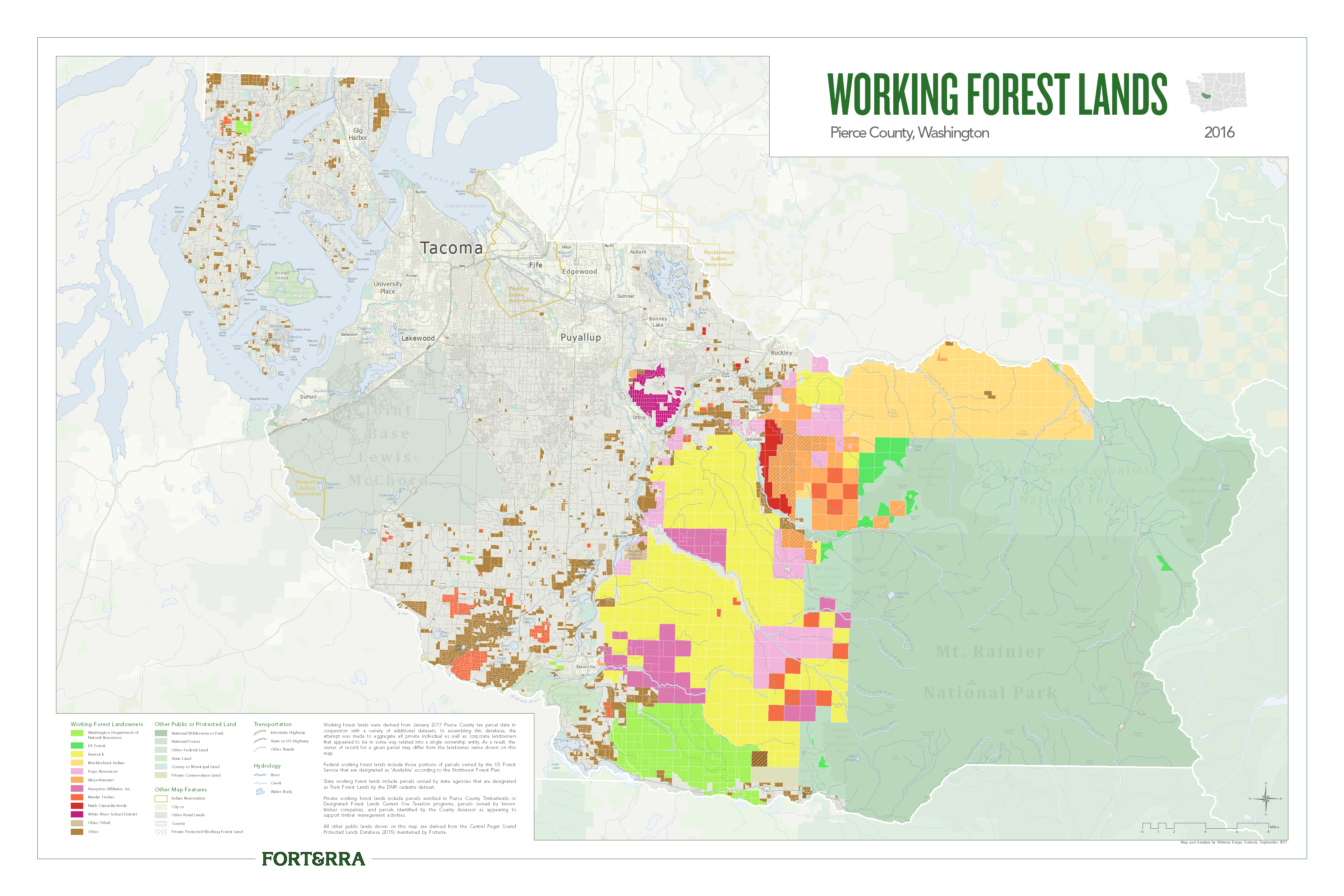
Working Forest Lands
Working forest lands owned by private and public entities in Pierce County, WA in 2016.
GIS Analyst
MS, Geospatial Technologies
The purpose of my capstone project was to develop a web application to collect data on land use preferences in order to explore the potential for conflict over the use of natural resources on public lands in Washington State. Many areas of public land have multiple uses, for example the same land could be used for both logging and recreation activities, and the ways in which those land use types are designated has the potential to spark conflicts between communities, stakeholder groups, and public agencies. This project resulted in an interactive web application to collect spatial data from participants regarding land-use preferences and values associated with national forests. A spatial analysis identified areas of potential conflict based on incompatible land use types, and which values were most cited for each land use preference. This analysis demonstrates how an online interface may be used to collect information from interested parties, and how that information could be used to anticipate conflict during national forest management planning. This would help improve communication between communities and public agencies, increase efficiency in the forest planning process, and ultimately reduce land use conflict.
Go to the ApplicationGenerates a raster of potential conflict areas from land use preference polygon inputs.
Automates the download of publicly available county tax parcel shapefiles.
Downloads Tweets related to a topic, runs a sentiment analysis, and maps the tweet locations.
Using LiDAR data to measure forest carbon in the Capitol State Forest.
Live global earthquake and U.S. buoy cam feeds.
An exploration of existing wildlife crossing structures and highway segments in the state.
Map of Washington State public lands.
Points of interest in the maritime city Gig Harbor, Washington.
Working forest lands owned by private and public entities in Pierce County, WA in 2016.
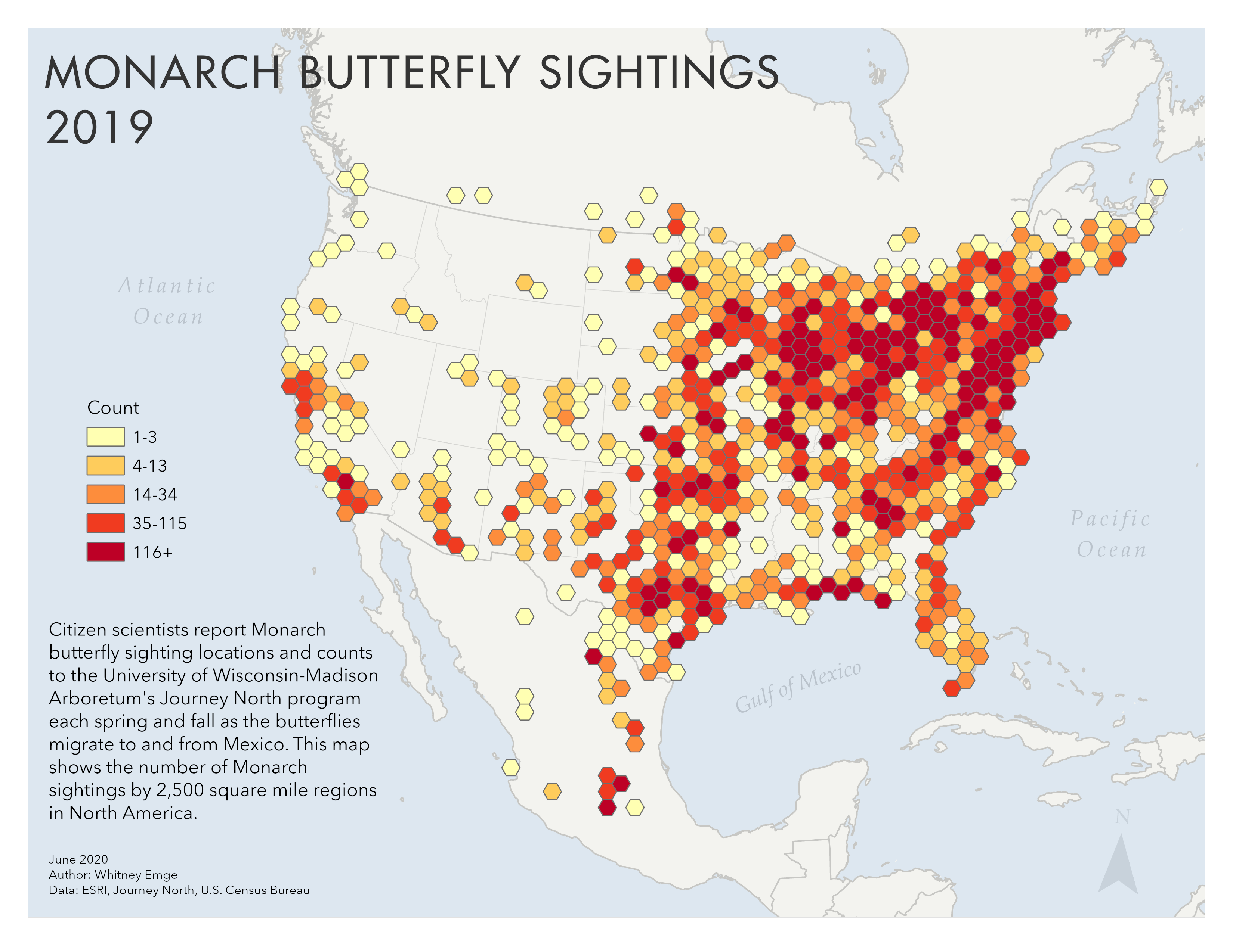
Sightings of Monarch Butterflies in 2019, as reported by citizen scientists.
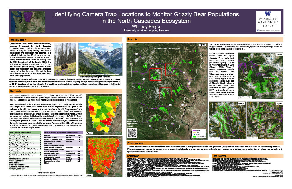
An analysis of grizzly bear habitat in the North Cascades of Washington.
This report was created to help inform efforts to preserve and enhance tree canopy in Thurston County, WA.
I see my work as a reflection of myself and strive to draw upon my strengths in creative problem solving and thoughtful communication to produce results. I value personal growth and approach my work with authenticity and a sense of humor while looking for opportunities to learn new skills. Supporting the balance between human needs and our natural spaces through application development and spatial analysis is an area in which I can leverage my focus and compassion to make meaningful contributions to the world.

The M.S. in Geospatial Technologies program provides advanced training in GIS, including the use and application of geospatial hardware, software, and data in urban and environmental planning scenarios, and the development and deployment of location-based mobile applications and management of web-based geospatial data.